


transporation information for visitors
getting around lee's summit
Safe and seamless transportation options for all. Lee’s Summit has transportation options designed to help visitors move easily between lodging, dining, and entertainment during the World Cup. Our transportation options connect you to the airports, FanFest, Kansas City Stadium, and Lee’s Summit. Planning ahead will ensure a smooth experience. Come join the 2026 Global Soccer Celebration at Lee’s Summit, Missouri.
TRANSIT/BUS
CONNECT KC26 Bus Transportation
Lee’s Summit will serve as a regional transportation hub during the World Cup through Connect KC26. Park-and-ride locations will offer service to Kansas City Fan Fest and matches at Kansas City Stadium.
Bus passes will be required. Parking at Stadium Direct locations will be limited and require advance booking.
The transit route will operate daily with bus arrivals/departures every hour in Lee’s Summit:
- Downtown Lee’s Summit located near 206 SW Market Street (one block west of the Amtrak Station).
To book tickets and learn more, please visit the Connect KC26 website.
Additional Bus Transportation Links:
AIRPORTS
Kansas City - Lee's Summit Regional Airport
The airport provides access to nearly 3,400 destinations and is located 3.5 miles north of Lee’s Summit’s vibrant downtown district.
- 13 miles to Kansas City Stadium
- 20 miles from Downtown Kansas City
- 5,501-foot runway
- Full Services Available, Including Concierge
The airport is open 24 hours, 365 days a year, and staffed daily from 6 a.m. to 8 p.m. For information call +1 816-969-1186.
Additional Airport Transportation Links:
train/rail
The Missouri River Runner
Ride the train all the way to St. Louis, Mo. Stops along the way include Jefferson City, Hermann and Kirkwood.
- Coach and Business Class
- Café service
- Wi-Fi available
- Reservations required for bicycles
Ticket information and pricing are available by calling +1 816-421-3622 or at Amtrak.com.
trails/bike & pedestrian
Lee’s Summit and the Kansas City region offer an extensive network of trails and bike routes that make it easy to explore the area without a car. Whether you're walking, running, or biking, these trails connect parks, neighborhoods, and nearby destinations across the region.
Use the resources below to explore popular routes including the Rock Island Trail, regional MetroGreen Trails & Bikeways, local Greenway Trails, designated bike routes, and additional cycling and pedestrian resources from BikeWalk KC.
ride share services
Ride share services such as Uber and Lyft operate throughout Lee’s Summit and the Kansas City metro area, providing convenient on-demand transportation. These services offer a flexible option for traveling to downtown Lee’s Summit, Kansas City Fan Fest, Kansas City Stadium, and other nearby destinations. Availability may increase during major events, and riders are encouraged to plan pickup and drop-off locations in advance.
car rentals
Visitors can access several national and local car rental providers throughout the Lee’s Summit and Kansas City area. Rental vehicles offer a convenient option for traveling between Lee’s Summit, downtown Kansas City, Kansas City Stadium, and other regional destinations. Advance reservations are recommended during major events.
LEE'S SUMMIT / KANSAS CITY COMMUNITY MAPS
Lee's Summit has a variety of places for you and your family to go explore and make memories.

KC ROADS & HIGHWAYS LIVE TRAFFIC MAP
VIEW MAP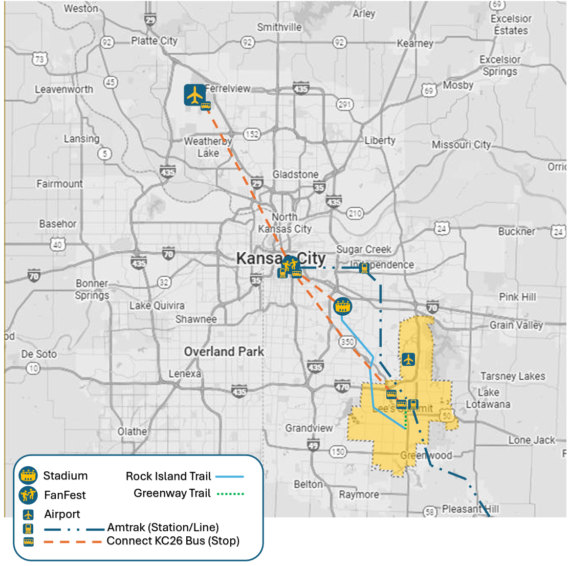
KANSAS CITY MAP
VIEW MAP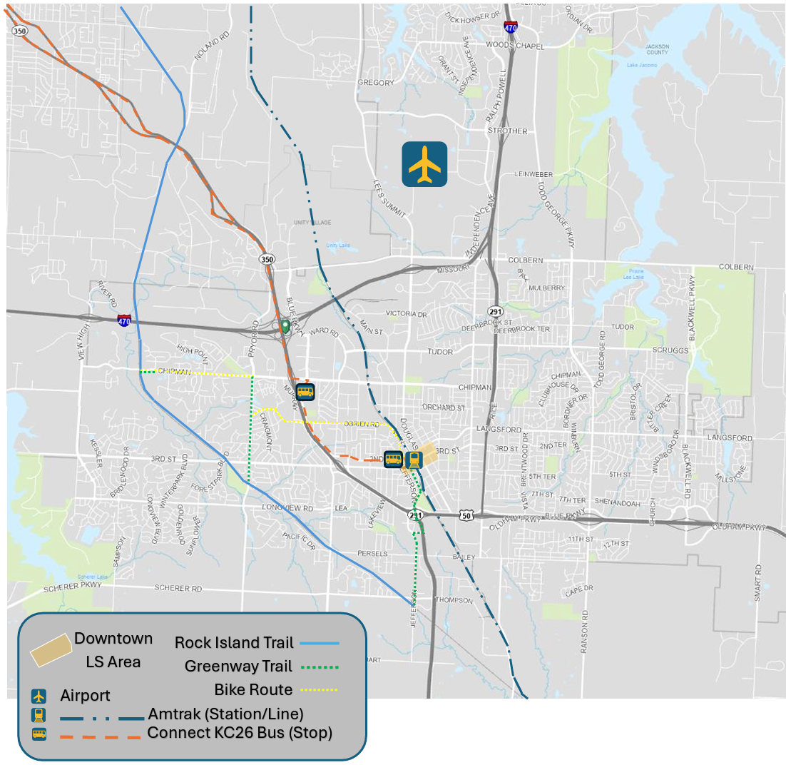
LEE'S SUMMIT MAP
VIEW MAP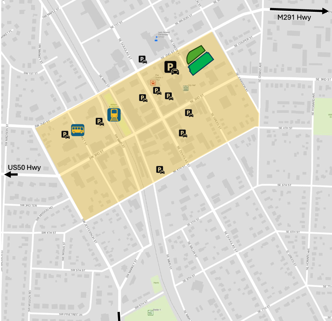
DOWNTOWN LEE'S SUMMIT MAP
VIEW MAPLEE'S SUMMIT PARKS AND REC MAP
VIEW MAPDOWNTOWN LEE'S SUMMIT BUSINESS MAP
VIEW MAPDOWNTOWN LEE'S SUMMIT PARKING MAP
VIEW MAPLEE'S SUMMIT MAP
VIEW MAPKC ROADS & HIGHWAYS LIVE TRAFFIC MAP
VIEW MAPKANSAS CITY MAP
VIEW MAPLEE'S SUMMIT MAP
VIEW MAPfaq's
frequently asked questions
What kind of traffic congestion or delay should be expected?
Traffic volume will increase during match days. Visitors are encouraged to use transit and ride share service options.
Is there a local bus service available and will there be room to ride?
Connect KC26 is operating an independent transit service for World Cup. Transit services offered by KCATA and other local bus service providers will continue throughout World Cup as regularly scheduled, but are not intended to serve the visitor demands of World Cup.
Does Kansas City – Lee’s Summit Regional Airport (LXT) accept international traffic?
While LXT can and does accommodate international flights; LXT cannot accommodate commercial airlines (e.g. commercially ticketed and scheduled service) and is not an equipped port of entry (US Customs and Immigration) into or leaving the United States of America. International flights must arrive or depart the United States of America through a properly equipped airport such as Kansas City International (MCI).
road closures & traffic updates
Temporary road closures may occur near event areas or along primary transportation routes during major events. This section will be updated as information becomes available to help residents and visitors plan ahead.
For the most current road closure information, please visit the City of Lee’s Summit road closure page below.